
Having an idea and turning that idea into something profitable are two very different things. Lots of people want to create an app, but the money-making aspect holds them back. Will you ever see a return on your investment?
I get asked dozens of questions about apps on a daily basis. But “how do you make money with an app” is definitely at the top of the list—which inspired me to create this guide.
Fortunately, there are lots of different ways to monetize an app.
Whether you’re building a new app for the first time or trying to make money with your existing app, I’ll explain everything you need to know about app monetization below.
How to Make Money With an App
Generally speaking, app monetization strategies fall into one of two categories—direct monetization and indirect monetization.
Direct monetization is definitely the most popular. In fact, the vast majority of the app monetization models covered in this guide will fall into that bucket. But before we get into the specifics, I want to quickly clarify the difference between these two app monetization methods.
Direct Monetization
As the name implies, direct monetization is money generated straight from your app.
If an iOS or Android user pays $1 to download your app from the Apple App Store or Google Play Store, the cash comes directly from the app. When someone uses your ecommerce app to buy something from your business, the sale is coming from your app.
Again, this is pretty self-explanatory. But it’s essential to understand how direct monetization works before we dive into indirect monetization.
Indirect Monetization
Indirect monetization isn’t quite as black and white. You can still make money by creating an app, but the actual dollar amount can’t necessarily be tied to the app itself.
The best example of indirect monetization is a standalone product or service that comes with a free app. In this situation, the app is secondary. You’re making money whether the app gets used or not. Having an app makes the product more appealing to prospective customers since it will ultimately improve the user experience.
Indirect monetization is extremely popular for software products. I’ll give you some actual examples of this shortly as we talk about app monetization strategies in greater depth below.
6 App Monetization Models and Strategies
There are six different ways to make money with an app. I’ll explain each one’s advantages and drawbacks to help you figure out the best way to monetize your app.
You’ll also see some real-life examples of apps using these monetization models successfully.
1. Paid Downloads
Charging users a fee to download the app is one of the simplest ways to make money with an app.
So how much should you charge? According to a 2020 study from Statista, the majority of paid apps cost less than $1.
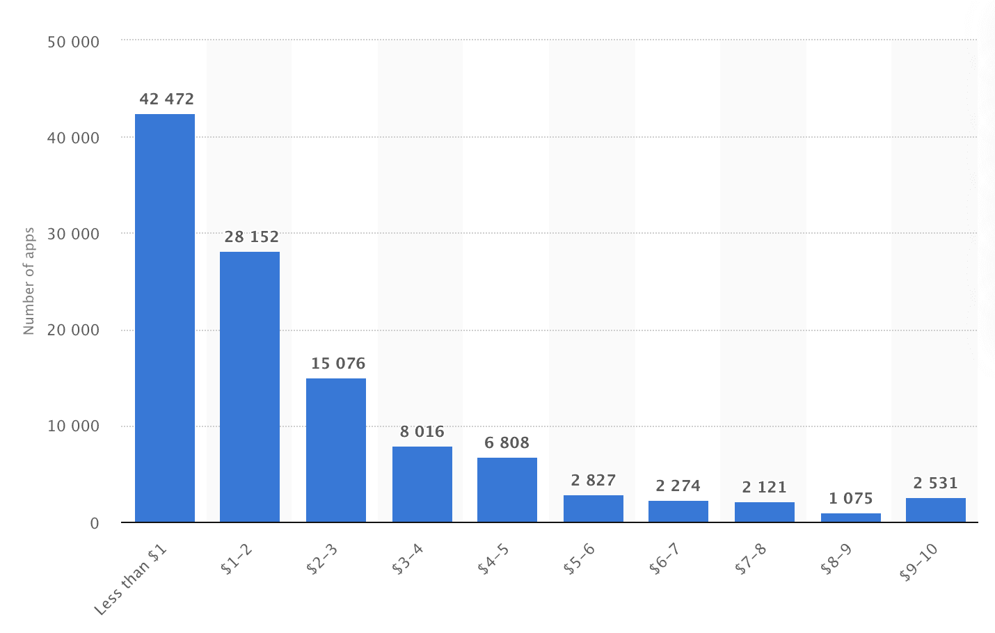
As you can see from the graph, most paid apps cost less than $5. This particular study only used data from the Google Play Store.
Statista also determined that the average cost of a paid app in the Apple App Store was $4.37. While this is slightly higher than the distribution of paid apps in the Google Play Store, it still falls in the less than $5 range.
You have the freedom to charge whatever you want for your app. But if you’re going to charge users a download fee, it should be in the range that they’re used to paying.
While pay-to-download is definitely a straightforward app monetization model, it does have its drawbacks. You can’t expect to get nearly as many downloads as you would for a free app. Some people won’t consider installing an app if it’s not free.
With that said, it’s more likely that paid users will be highly engaged.
Anyone who pays for a download will want to get the most out of their investment. If those people are using the app frequently, you could potentially make even more money from them with other app monetization models on our list.
2. In-App Purchases
The in-app purchases monetization model can be used for both free and paid apps alike. You can use this method for physical and virtual products.
Gaming apps love to leverage the in-app purchase methodology for virtual coins or experience upgrades. For example, users playing a mobile gaming app could spend money to unlock a new vehicle, weapon, map, or something along those lines.
Pokemon Go is a great example of a free mobile app that makes money from in-app purchases.
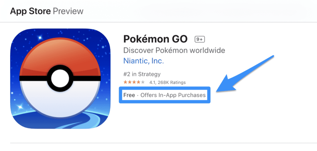
According to Video Games Stats, Pokemon Go has generated more than $3 billion in revenue as a free app.
This revenue comes from roughly one billion downloads. But since people aren’t paying to download the app, how does it make money? In-app purchases. The app sells “PokeCoins.” This virtual currency can be used to pay for upgrades within the app that improve the gaming experience.
But mobile games aren’t the only way to monetize an app with in-app purchases. Ecommerce websites can build an app as a way to increase mobile sales.
If a customer buys a shirt, pair of sneakers, book, watch, or whatever you’re selling online from your app, it falls into this category as well. Using an app to make money is a no-brainer for anyone who already sells physical or digital products online.
3. Subscriptions
Subscriptions are an excellent way to generate recurring revenue with an app. The Apple App Store and Google Play Store both make it easy for you to set up a subscription business model with your app.
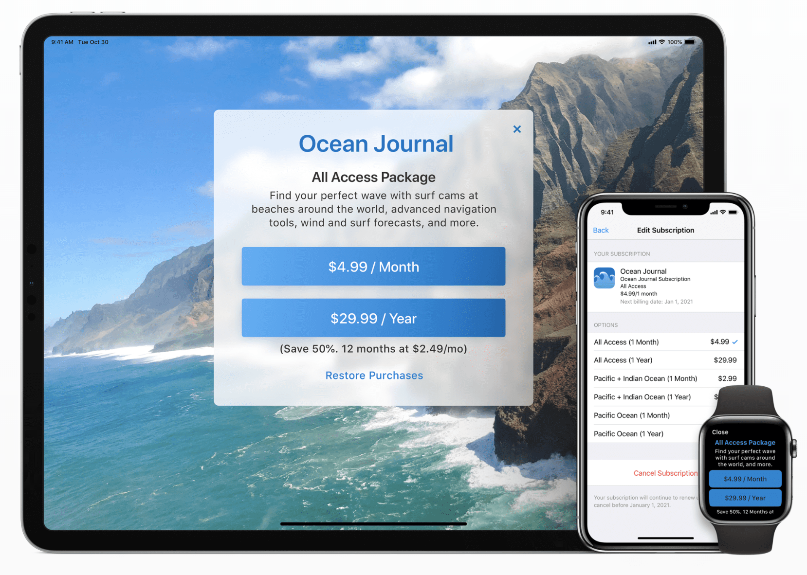
Users only need to sign up for a subscription once, and they’ll continue to get charged on a recurring basis until they manually cancel the subscription.
In most cases, subscription apps are billed on a monthly basis. But you can set up annual or quarterly billing cycles as well. It’s common to offer a better monthly rate for longer subscription terms, as shown in the example above.
Subscription apps could be applied to a wide range of industries and potential use cases.
If you’re creating a fitness app, you can charge users a monthly subscription for access to workouts, videos, and training regimens. Even a small business owner, like a local dry cleaner, could leverage the subscription model to offer pick-up and delivery cleaning services.
An excellent subscription-based app, called PepTalks, was recently built using BuildFire’s platform. App users pay a monthly fee to receive motivational words delivered to their devices via push notification on a daily basis. You can read the full PepTalks customer story here to learn how one person took a simple idea and monetized it with an app.
4. Freemium Model
The freemium app model is essentially a mix between subscriptions and in-app purchases. Technically speaking, it could potentially fall into either category, but this is definitely worth mentioning on his own.
To clarify, the term “freemium” comes from combining the words “free” and “premium.” Free + premium = freemium; get it?
So offering your app for free is the first step to using the freemium monetization strategy. Next, you need to offer different versions of your app—free and premium.
The idea here is to offer a free version with basic features and an upgraded version that delivers a better user experience. For example, let’s look at the Pandora mobile app subscription options.
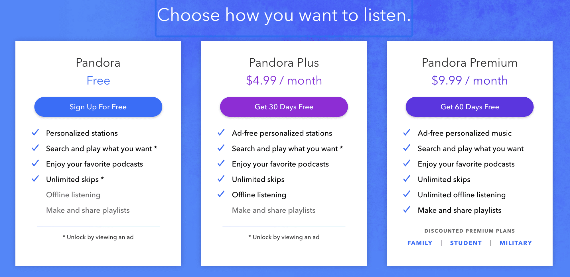
This Internet radio service has multiple plans, including a free version.
Anyone can download the app for free and listen to music for free. However, you’ll be interrupted with ads between songs. There are also some limitations and contingencies in terms of skipping songs, searching for songs, and playing what you want.
The free version is fine, but if you want to get the most out of this app, you’ll need to get a paid subscription.
With freemium apps, you still need to make the free version good enough. For example, if the free version of Pandora only played one minute of each song, nobody would use it. So you’d have a tough time converting those free users to paid subscribers.
You’ll also need to make sure the cost associated with the premium features are justified. If the only difference between the two versions is a minor inconvenience, people won’t feel the need to upgrade.
Another way to entice premium upgrades is by offering extended free trials of those versions. Some users might not know what they’re missing until they try it out. So don’t be afraid to offer a premium month for free.
5. Advertisements
Ad revenue is an extremely popular app monetization strategy. With this method, you’re selling space within your app for advertisements. Some of you might be familiar with this model if you display ads on your website.
According to a recent survey of the world’s top app publishers, mobile advertising is the most effective method of app monetization.
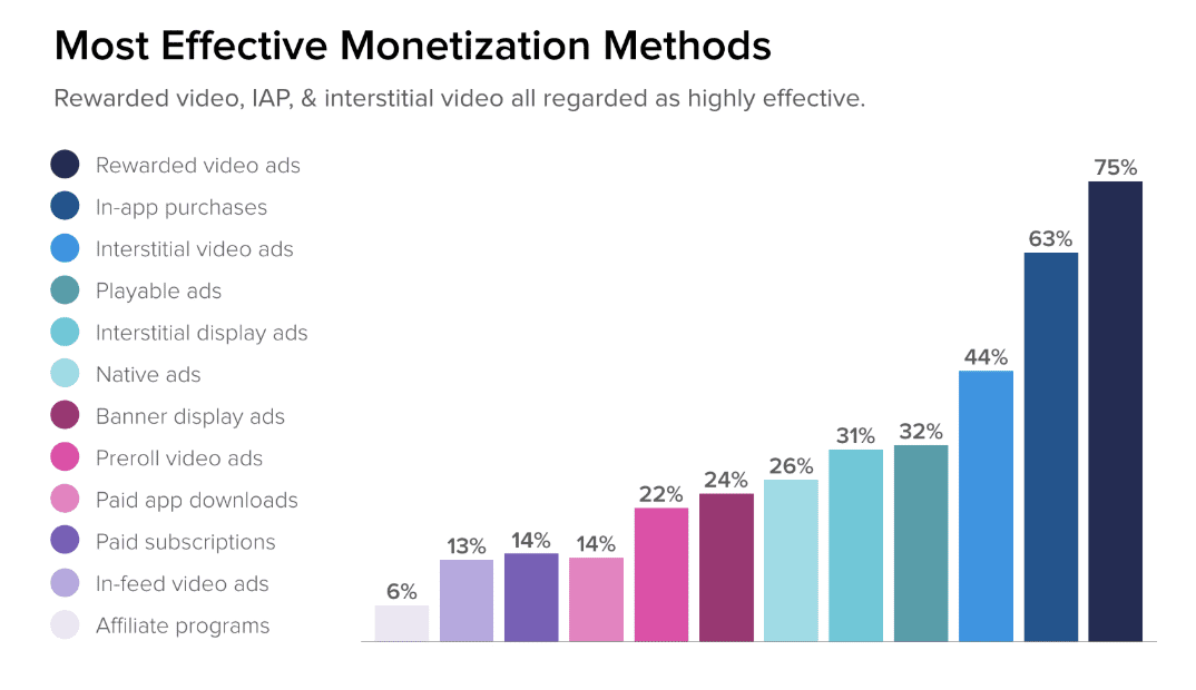
As you can see from the chart, 8 of the top 12 methods on the list are ads—including 4 of the top 5.
App advertising can come in all different shapes and sizes. Not only are there different types of ad formats (video ads, banner ads, native ads, pop-ups, interstitial ads, etc.), but there are also different revenue models within this category:
- CPC (cost-per-click)
- CPI (cost-per-install)
- CPA (cost-per-action)
- CPM (cost-per-mile)
- CPV (cost-per-view)
How you’re paid and how much you get paid depends on a wide range of factors. For example, simply displaying a banner ad with a CPV revenue model usually won’t pay as much as CPC or CPI model.
Check out our guide on the top mobile ad networks to help facilitate ads within your app. This resource contains an in-depth description of the various revenue models as well. Ad networks help ensure the ads displayed within your app are relevant to your target audience.
While in-app advertisements are popular and profitable, they’re definitely not for everyone. Sometimes ads can hinder the user experience, and ultimately make your app less desirable. So you need to take this into consideration before blindly adding ads to your app.
6. Product Extensions
A product extension falls into the indirect monetization category, which I mentioned earlier.
This strategy is a great way to generate revenue for your product, service, or business, but the money won’t be tied directly to actions within the app itself. Let me give you an example to explain what I mean.
Take a product like QuickBooks. For those of you who aren’t familiar with this name, QuickBooks is an online accounting software used by 7+ million customers worldwide. The platform controls more than 50% of the accounting software market share, which is why it makes such a great example.
QuickBooks is a paid software. But anyone who buys the software gets to use the iOS and Android mobile app for free.
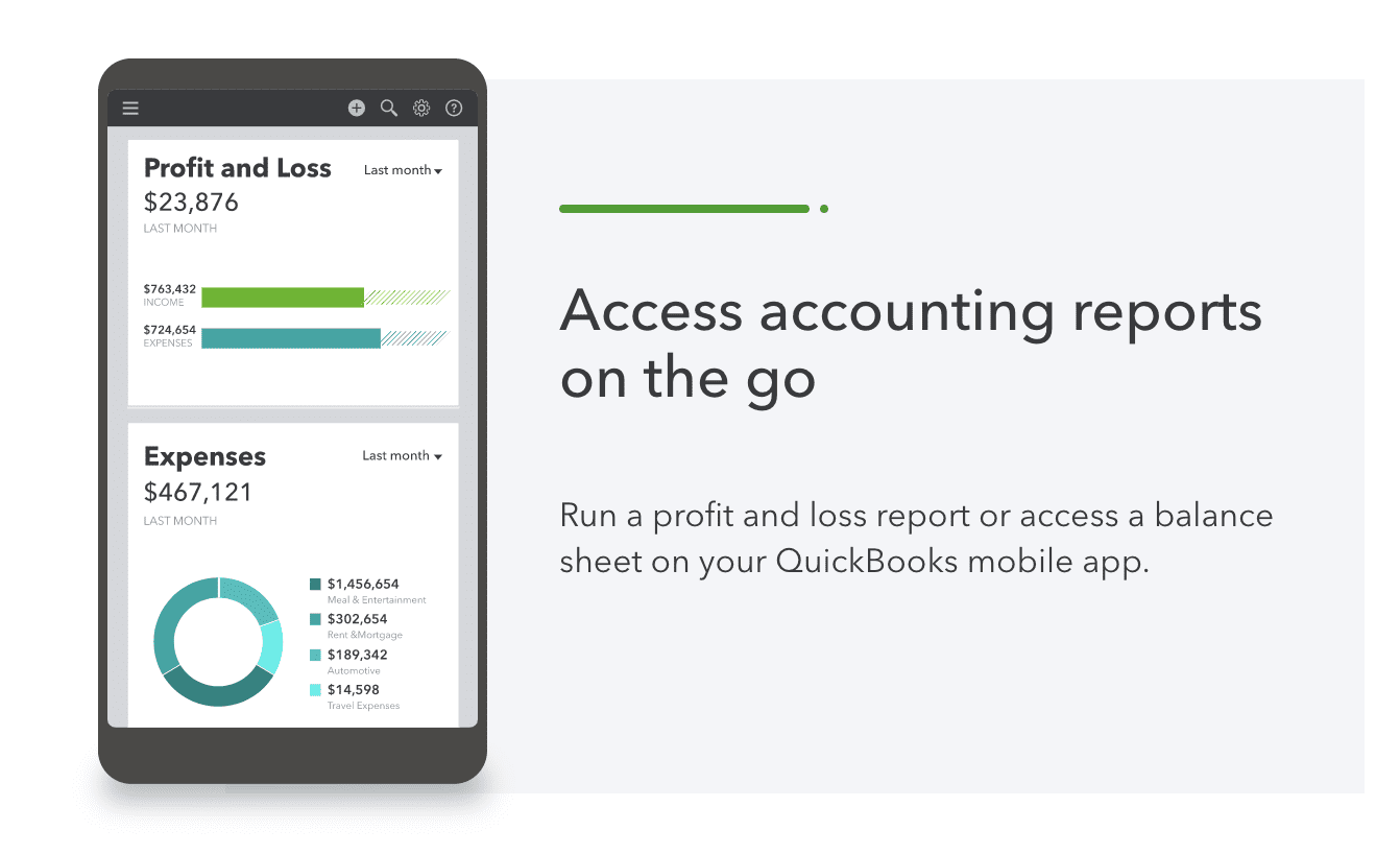
The app itself doesn’t directly generate any revenue. You can sign up for a QuickBooks subscription and never use the app.
However, people love apps. Being able to access the software from anywhere with a native mobile experience adds value to the product.
Having an app as a product extension also helps differentiate you from the competition. If your product comes with an app and others don’t, then it gives you a significant edge. Your business will automatically be more appealing to consumers who are shopping around for a product in your category.
How Do Free Apps Make Money?
If you don’t want to charge users for downloads, you might be wondering how to make money with a free app. Don’t panic—you can still make lots of money without charging for app installations.
Refer back to the app monetization strategies we discussed above; five of the six methods can be applied to free apps.
- In-app purchases
- Subscriptions
- Freemium apps
- Advertisements
- Product extensions
All of these monetization models can be leveraged with a free app. You could even use more than one method for your free app.
For example, let’s say you plan to use the in-app purchases monetization strategy. You can leverage advertisements as well. Using multiple monetization methods will help you make money with a free app.
The vast majority of app installations from the Apple App Store and Google Play store are free downloads.
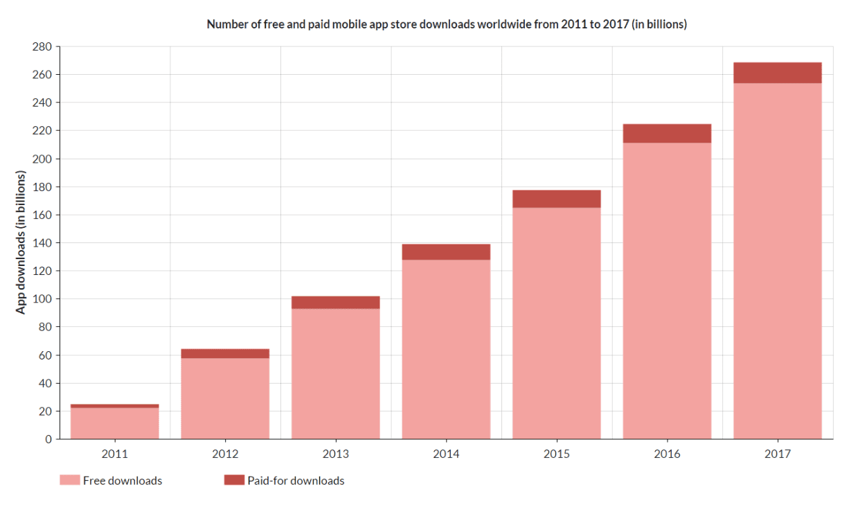
Furthermore, 98% of global app revenue comes from free apps. Check out our extensive guide on mobile app download and usage statistics for other relevant facts like this.
In short, don’t feel pressured to charge for app downloads—you can still make money with a free app.
How to Choose the Right Monetization Model For Your App
With so many app monetization methods to choose from, how can you decide which method is best for your mobile application?
There’s no single answer to this question. You’ll have to weigh the pros and cons that we’ve discussed above.
Some industries and app types are easier to determine than others. For example, in-app purchases would be the obvious monetization model for an ecommerce app. Using ads for an ecommerce app or charging for downloads probably won’t be the best idea. Ads can take attention away from the products you’re selling, and making users pay extra for the ability to buy products through the app doesn’t make a ton of sense either.
Depending on your app type, you could experiment with different monetization models. Let the data do the talking for you—track engagement and other valuable KPIs to figure out which method will be the most profitable for your app.
Do I Need to Monetize My App?
In most cases—yes.
Without a monetization strategy, your app won’t make any money. You’ll want to make sure you can recoup the cost for app development, and eventually turn a profit for your efforts.
But with that said, not every app needs to be monetized. Some apps can make money without an actual monetization strategy. For example, let’s say you build an internal workforce app. An HR mobile app or an employee communication app doesn’t need to be monetized.
You wouldn’t charge your employees to download an app or interrupt their experience with advertisements. But building an app for these purposes can ultimately save money in labor and productivity costs. Your profit total profit margins will increase elsewhere, even though the app itself won’t directly drive revenue.
Conclusion
App monetization can be a challenge for app developers and business owners. But making money with an app doesn’t need to be complicated.
The first step is understanding the different ways to make money with an app. Then it’s just a matter of figuring out which ones work for you.
This guide covers everything you need to know about app monetization. So use it as a resource as you’re going through the process.